With hundreds of ZephIR deployments globally, the ZephIR system offers the best bankable LIDAR wind data.
ZephIR has operated successfully through Canadian winters and Australian summers. Customers have financed projects using ZephIR data. Banks’ Engineers recommend ZephIR onshore and offshore to both complement and replace traditional masts.
- 10m to 200m wind profile - speed, direction, turbulence
- Speed accuracy* < 0.5%
- Direction accuracy* < 0.5°
- 50 data points per second
- - 25°C to + 40°C operation (extendable operating range)
- 100W average power draw**
- 5 years experience in the field
- Industry approved calibration
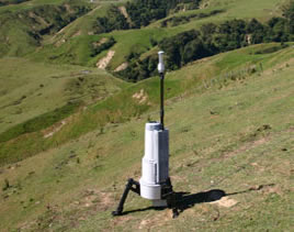
The ZephIR system uses the Doppler shift of the returned laser beam to determine wind speed. The monitored height is determined by the focal length of the system. Issues of cloud interference have now been tackled to produce the highest data availability of any system of its type.
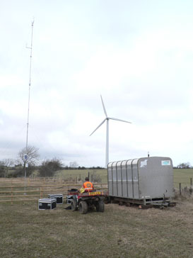
Wind Measurement International offers a full range of automated, on-line remote power options and secure, rigid, easy-to-deploy foundations and enclosures which leave no footprint.
Our standard rental and installation package includes a 9KVA diesel generator, steel I-beam on railway sleeper foundations, secure enclosure and online monitoring of fuel level and battery charging. Together with our 12 or 18 m met mast options, we can provide long term wind roses with short term wind profiles up to 200 m. The short term profiles can be extrapolated across the whole year with the help of our shelter mapping software.
Coupled with our complex terrain modelling software, the data from the 12 or 18m mast and ZephIR can be used to calculate the likely turbulence at the ZephIR monitored heights.
Each unit is calibrated before and after deployment by Natural Power, supplier of the ZephIR system.
For reduced cost off-shore systems WMI is in the process of developing a buoyant, sealed, gyroscopic established solution with a high volume fuel store to maximise availability even in the roughest seas.